Microsoft word - appendix 3 stratford sites ed 2.doc

Warwickshire County Council
Stratford on Avon District
Local Development Framework Core Strategy
Historic Environment Assessment
of Proposed Strategic Sites
Stratford on Avon District Local Development Framework Core Strategy
Historic Environment Assessment of Proposed Strategic Sites.
Contents
Executive Summary
Methodology− Historic Environment Assessment
− HER Monument Record Selection
Historic Environment Assessment
Site Specific Historic Landscape Characterisation Data.
Site Specific Historic Environment Record Data.
The assessment of the archaeological potential of each site, the likely impact of the past and future use of the sites on archaeological deposits, and the archaeological planning recommendations has been primarily undertaken by the Warwickshire Museum Planning Archaeologist, Anna Stocks.
The HLC assessment and comments on the sensitivity of each site's historic character to change have been undertaken by the Warwickshire Museum Historic Landscape Characterisation Officer, Ben Wallace.
The production of the HER maps and the extraction of HER data for inclusion within the appendix was undertaken by Giles
Carey, Assistant Historic
Environment Officer.
Archaeological Information and Advice,
Warwickshire County Council
Shire Hall, PO Box 43,
Warwick, CV34 4SX(01926) 412276. http://timetrail.warwickshire.gov.uk
Executive Summary
A basic archaeological assessment has been undertaken of each of a series of sites proposed for inclusion in the Stratford on Avon Local Development Framework as potential development sites. The study has been commissioned by Stratford on Avon District Council. All relevant data held by the Historic Environment Record (HER) office has been consulted during the course of this assessment.
This document presents the results of that assessment, and includes:
− a summary of the state of archaeological knowledge about each site;
− the likely impact that the past uses of each site would have had on any
archaeological deposits which previously survived;
− the potential for previously unknown archaeological sites to survive
across each site;
− the Historic Environment Significance (including Historic Landscape
Character) of each site and its sensitivity to change.
A preliminary archaeological planning recommendation is also made for each site. In a number of cases this includes a recommendation for more detailed study
Copies of the relevant HER and HLC data considered during the course of the assessment have been included, with maps, in the appendices to this report.
It should be noted that this is a basic level assessment of the archaeological potential of these sites, using only information held by the HER office. It is likely that further archaeological assessment of a wider range of sources would further inform the assessment of the archaeological implications of the proposed development of these sites. The archaeological planning recommendation may change, following the more detailed examination of individual sites. Moreover, additional information may be received by the HER office in future, altering our understanding of the archaeology of a particular area.
It should also be noted that the Warwickshire Historic Landscape Characterisation Project is an ongoing project due to finish at the end of 2008. As such, although all off the Proposed Strategic Sites are covered by characterisation, some of the analysis is limited and in progress. The summaries are general summaries of the historic landscape character of each area without any district wide or county wide analysis for comparison.
1. Methodology
Historic Environment Assessment
This assessment has considered the archaeological potential of the Proposed Strategic Sites (PSS), the likely impact of the past use of the sites on any archaeological deposits across the site and the likely impact of the proposed development of each of the sites upon any known, and/or unknown archaeological deposits which survive across each of the Proposed Strategic Sites. It has also considered the Historic Landscape Character (HLC) of each site, and this character's sensitivity to change.
Section 1 of this document presents the results of that assessment, and includes:
− a summary of the state of archaeological knowledge about each site;
− the likely impact that the past uses of each site would have had on any
archaeological deposits which previously survived;
− the potential for previously unknown archaeological sites to survive
across each site;
− the Historic Environment Significance of any such archaeological
features and their sensitivity to change.
− The Historic Landscape Character of each site and this character's
sensitivity to change.
An initial archaeological planning recommendation is also made for each site.
Appendix One contains the HLC data considered during the course of the assessment.
The archaeological assessment has been undertaken by archaeologists in the Information and Advice section of the Warwickshire Museum Field Services. All relevant data readily available to the Warwickshire Museum Field Services has been consulted during the course of this assessment. This primarily comprises the data held by the Historic Environment Record (HER) office, and includes:
− HER database records;
− HLC data held within the HER database.
− Historic, modern and geological maps;
− Modern and historic aerial photographs;
− Data on past archaeological planning recommendations held on the
HER consultations module;
− ‘Grey literature' reports on previous archaeological fieldwork
undertaken within Warwickshire;
− Secondary sources.
It should be noted that the absence of known archaeological sites in the immediate vicinity of a proposed development site does not necessarily indicate an absence of archaeological potential. There are a number of reasons for archaeological sites not
having been previously identified across an area; for example, due to a previous lack of investigation, or an underlying geology or agricultural regime which hinders cropmark generation. Absence of evidence cannot therefore be taken as evidence of absence. The assessment of the archaeological potential of each site takes this into account.
It should be noted that this is a basic level assessment of the archaeological potential of these sites, using only information held by the HER office. It is likely that further archaeological assessment of a wider range of sources, for example records held by the County Record Office, aerial photographs held by the National Monuments Record, information on past disturbance across a site held by landowners, would further inform the assessment of the archaeological implications of the proposed development of these sites. The archaeological planning recommendation may change with the more detailed examination of individual sites. Moreover, additional information may be received by the HER office in future, increasing our understanding of the archaeology of a particular area.
The significance of hedges in respect of the Hedgerows Regulations 1997 has not been assessed here.
The planning recommendations have been drawn up within the context of the Planning Policy and Guidance (primarily PPG16 – Archaeology and Planning) currently applicable. New guidance, replacing PPGs 15 and 16, is due to be published, for implementation along with the Draft Heritage Projection Bill published in April 2008. Recommendations may require modification where appropriate in the light of the new regulatory framework.
HER Monument Record Selection
Appendix Two contains copies of selected HER monument records for known archaeological sites in the vicinity of each of the Proposed Strategic Sites, and maps showing their locations.
These HER maps and reports include all HER monuments within a 200m radius of each Proposed Strategic Site and any further HER monuments relevant to this archaeological assessment which lie within a 1km radius of these sites. A judgement on the relevance of each monument within a 1km radius of the site was made by the Warwickshire Museum Planning Archaeologist.
Information considered not relevant to the archaeological assessment includes monuments which were located away from the immediate vicinity of the Proposed Strategic Sites and that are known not to extend across the development site (e.g. a post-medieval park with a known boundary 400m away from the site), and lone findspots located a significant distance from the Proposed Strategic Sites. In addition, duplicated information, for example a record of a medieval building which lies within an area defined as being a known area of medieval settlement, has been removed from these datasets.
2. Historic Environment Assessment.
Caveat:
It should be noted that this is a basic level assessment of the archaeological
potential of these sites, using only information held by the HER office. It is likely that
further archaeological assessment of a wider range of sources, for example records
held by the County Record office, aerial photographs held by the National
Monuments Record, information on past disturbance across a site held by
landowners, would further inform the assessment of the archaeological implications
of the proposed development of these sites. The archaeological planning
recommendation may change with the more detailed examination of individual sites.
Moreover, additional information may be received by the HER office in future,
increasing our understanding of the archaeology of a particular area.
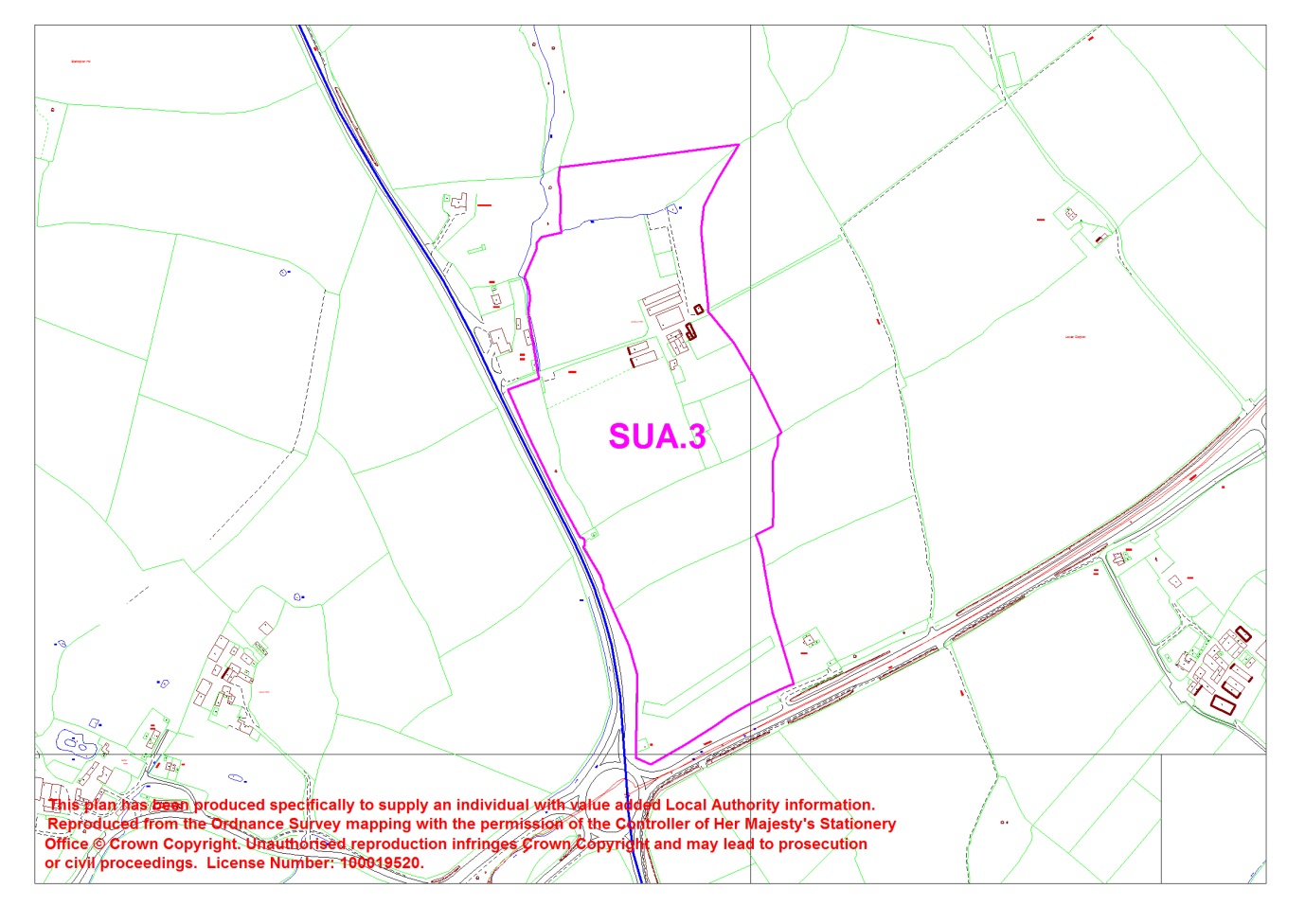
East of Birmingham Road, Stratfird-upon-Avon
Site size: 15.56ha
Geology: Mercia Mudstone
Past Disturbance:
It is probable that the majority of this PSS has been in agricultural use since at least
the medieval period. Whilst this activity may have caused some damage to any
archaeological deposits predating or associated with this use, this activity in unlikely
to have caused extensive damage.
The field to the immediate South of Langley Farm was in use as an orchard for part of the 20th century (3rd Ed. OS map). The intensity of the tree planting which has previously taken place across this part of the site is not known, this may have had a significant localised impact across parts of the development site.
Scheduled Monuments within proposed LDF site:
Scheduled Monuments within 200m of proposed LDF site:
Known archaeological sites within proposed LDF site:
Langley Farm, shown on 1st Ed. OS map (1886)
Known archaeological sites within 200m of proposed LDF site:
Undated cropmark enclosure, 400m E of Burton Farm
Turnpike Road from Edge Hill to Birmingham via Stratford
Sealt Stret, Early Medieval Saltway
Feldene Stret, Anglo-Saxon routeway
Archaeological potential of the PSS:
This site lies to the north east of medieval settlement at Bishopton, part of which
survives as earthwork features representing crofts, the site of a church and
fishponds. The area of the PSS is likely to have been in the wider agricultural
hinterland of this settlement from the medieval period onwards.
Although few archaeological sites have been previously recorded in the immediate vicinity of the site, evidence for prehistoric and Roman activity has been recorded from the wider area. The absence of known archaeological sites from the immediate vicinity of this site may be due to a lack of previous archaeological investigations across this area, rather than an absence of activity during the premedieval periods. There is therefore a potential for previously unknown archaeological deposits, pre dating the medieval and later agricultural use of this site, to survive across this area. Any such deposits are likely to be of regional or local significance.
Historic Landscape Character of the PSS:
This site covers three distinct HLC types; in the northern part of the site is a pre
1880s Farm Complex with associated Paddocks attached to the west of the farm. In
the southern part of the site are Piecemeal enclosed fields which form part of a
larger fieldscape of Piecemeal enclosed fields that surround the farm and paddocks
to the west, north and southeast. To the northeast of the site are some Large
Rectilinear fields.
In the wider area the Historic Landscape Character is formed of dispersed historic farmsteads, pre 1880s in origin, often with some associated paddocks next to them. These are sitting within a predominantly mixed fieldscape of large rectilinear fields and post-second world war very large amalgamated fields.
Sensitivity to change:
The groundworks associated with the proposed development of this site would be
likely to have a significant negative archaeological impact upon any archaeological
deposits which survive across this site.
The fields in the southern part of the site are part of a wider fieldscape of Piecemeal Enclosure which probably has a pre 19th century date of origin and has evidence of ridge and furrow suggesting this once formed part of an earlier, possibly medieval,
landscape. Any development, particularly in these fields, will alter the historic landscape character of this area and have an effect on the surrounding character.
Archaeological Planning Recommendation for the PSS:
A programme of archaeological evaluative fieldwork should be undertaken prior to
the determination of any application to develop this site. This fieldwork will help to
establish the presence or absence of archaeological remains or artefacts across the
site, and, if present, their character, extent and state of preservation. It will also
provide information useful for identifying potential options for minimising or avoiding
damage to them. This fieldwork may identify archaeological deposits of regional or
national importance, which may be worthy of preservation in situ. The availability of
this information prior to the determination of any planning application submitted will
enable an informed and reasonable planning decision to be reached, and the
application modified if appropriate.
Appendix One.
Site Specific Historic Landscape Characterisation
Site No: SUA.3
HLC Type(s):
Fieldscape (Piecemeal Enclosure) Fieldscape (Paddocks and Closes) Settlement (Farm Complex Pre 1880s)
Other HLC Types in vicinity:
Fieldscape (Piecemeal Enclosure) Fieldscape (Paddocks and Closes) Fieldscape (Other Large Rectilinear Fields) Settlement (Farm Complex Pre 1880s)
Summary:
This site covers three distinct HLC types; in the northern part of the site is a pre 1880s Farm
Complex with associated Paddocks attached to the west of the farm. In the southern part of the site are Piecemeal enclosed fields which form part of a larger fieldscape of Piecemeal enclosed fields that
surround the farm and paddocks to the west, north and southeast. To the northeast of the site are some Large Rectilinear fields.
In the wider area the Historic Landscape Character is formed of dispersed historic farmsteads, pre 1880s in origin, often with some associated paddocks next to them. These are sitting within a predominantly mixed fieldscape of large rectilinear fields and post-second world war very large amalgamated fields.
Points to note:
The fields in the southern part of the site are part of a wider fieldscape of Piecemeal Enclosure
which probably has a pre 19th century date of origin and has evidence of ridge and furrow suggesting this once formed part of an earlier, possibly medieval, landscape. Any development, particularly in these fields, will alter the historic landscape character of this area and have an effect on the surrounding character.
Appendix Two.
Site Specific Historic Environment Record Data.
The following Historic Environment Record (HER) maps and reports do not include all of the known archaeological sites or monuments within the 1km radius of the Proposed Strategic Sites. Information considered not relevant to this particular archaeological assessment has been removed from these data sets.
These HER maps and reports do, however, include all HER monuments within a 200m radius of each Proposed Strategic Site and any further HER monuments relevant to this archaeological assessment which lie within a 1km radius of these sites. A judgement on the relevance of each monument within a 1km radius of the site was made by the Warwickshire Museum Planning Archaeologist.
Information considered not relevant to the archaeological assessment includes monuments which were located away from the immediate vicinity of the Proposed Strategic Sites and that are known not to extend across the development site (e.g. a post-medieval park with a known boundary 400m away from the site), and lone findspots located a significant distance from the Proposed Strategic Sites. In addition, duplicated information, for example a record of a medieval building which lies within an area defined as being a known area of medieval settlement have been removed from these datasets.


SUA.3 – East of Birmingham Road, Stratford-upon-Avon
Please note: This map and the following report do not include all of the known archaeological sites or monuments within the vicinity of the Proposed Strategic Sites. Information considered not relevant to this archaeological assessment has been removed from these data sets.
Warwickshire Historic Environment Record
Tel: 01926 412734
PO Box 43, Shire Hall, Warwick CV34 4SX
Number of records: 19
HER Number
Site Name
Record Type
Site of Church of St Peter, Bishopton
The site of the Church of St Peter which dates to the Imperial period. The church was located in Bishopton. The building has been demolished but the graveyard remains.
HER Number
Site Name
Record Type
Ridge & Furrow near Bishopton
Ridge and furrow was identified through trial trenching. It is also visible on LiDAR imagery.
HER Number
Site Name
Record Type
Clopton Cottage garden, Bishopton, Stratford
Cottage with garden and orchard. Demolished and site developed.
HER Number
Site Name
Record Type
Undated Enclosure 400m E of Burton Farm
The site of an undated enclosure which is visible as a crop mark on aerial photographs. Appears to be a geological or natural feature. It is situated 600m north of Bishopton.
HER Number
Site Name
Record Type
Royal Victoria Spa, Bishopton
The site of Royal Victoria Spa dating from the Post Medieval to the Imperial period. The gardens associated with the spa were created during the Imperial period. It is situated north of Bishopton. Villa-type pleasure grounds with walks; pond.
HER Number
Site Name
Record Type
The Stratford-upon-Avon Canal
The Stratford on Avon Canal dates from the Imperial period. It runs between the Bancroft Basin in Stratford and the Worcester and Birmingham Canal at Kings Norton, Birmingham.
HER Number
Site Name
Record Type
Turnpike Road from Edge Hill to Birmingham
A toll road which was established during the Post Medieval period. It continued to be used during the Imperial period. It was part of one of the London to Birmingham routes. The road ran between Edge Hill and Birmingham via Stratford.
HER Number
Site Name
Record Type
Chapel of St Peter, Bishopton
The site of the Chapel of St Peter. The remains of the chapel are visible as an earthwork and are known from documentary evidence. It was demolished and rebuilt on a new site during the Imperial period. The site is situated 750m south of Bishopton Hill.
HER Number
Site Name
Record Type
Deserted Post Medieval Settlement at
The site of a deserted settlement dating to the Post Medieval period. Remains of the settlement are visible as an earthwork. Features include the site of a church and crofts. It is situated 750m south of Bishopton Hill.
HER Number
Site Name
Record Type
Deserted Settlement at Bishopton
The site of a deserted settlement dating to the Imperial period. The remains of the settlement are visible as an earthwork. Documentary evidence shows a reduction in houses occupied: 11 in 1841 and 4 by 1871. It is situated 750m south of Bishopton Hill.
HER Number
Site Name
Record Type
Fishponds at Bishopton Deserted Settlement
Fishponds used for the breeding and storage of fish, which are of the Medieval/ Post Medieval period. They survive as earthworks and are situated 700m north west of Bishopton, Stratford on Avon.
HER Number
Site Name
Record Type
Midland Railway (Hatton, Stratford &
The Hatton Stratford on Avon and Honeybourne sections of the Midland Railway. They date from the Imperial period, and are marked on the Ordance Survey first edition 25" map.
HER Number
Site Name
Record Type
Sealt Stret (Early Med saltway)
The site of a road known as a saltway. It dated to the Early Medieval period and is known from documentary evidence to be called Sealt Stret. It would have run from Droitwich, but this section has been traced running between Bishopton and Salford.
HER Number
Site Name
Record Type
Avenue House grounds, Bishopton
A garden dating from the Imperial period, which includes walks, an avenue, a paddock and an orchard. It is marked on the Ordnance Survey map of 1886 and is located in Bishopton.
Recommended for inclusion on Local List by Lovie.
HER Number
Site Name
Record Type
Avenue House, Bishopton
The site of a villa which was built during the Imperial period. It is marked on the Ordnance Survey map of 1886. It is located in Bishopton.
HER Number
Site Name
Record Type
Feldene Stret (Anglo-Saxon routeway)
A trackway dating to the Early Medieval period. This trackway is probably Feldene Stret, the road to the Feldene. It is known from documentary evidence. This route is now the existing Birmingham to Stratford Road.
HER Number
Site Name
Record Type
Aelfric's Bridge, Bishopton
Aelfric's Bridge, the probable site of an Early Medieval bridge for which there is documentary evidence in the early 11th century. The bridge was located at Bishopton.
HER Number
Site Name
Record Type
Site of Deserted Settlement near Burton Farm
The site of a deserted settlement dating to the Medieval period. The remains of the settlement are visible as an earthwork with features including a church site and crofts. It is located 750m south of Bishopton Hill.
HER Number
Site Name
Record Type
Site of a medieval wood called Clopton Grove.
Source: https://www.stratford.gov.uk/files/seealsodocs/169761/ED492a%20Proposal%20SUA3%20Historic%20Environment%20Assessment.pdf
Meconium Aspiration Syndro y first intestinal discharge from newborns is meconium ◦ a viscous, dark green substance composed of intestinal epithelial cells, lanugo, mucus, and intestinal secretions, such as bile. Chief, Division of Neonatology ◦ Intestinal secretions, mucosal cells, and solid elements of swallowed amniotic fluid are the 3 major solid constituents of meconium.
Latitude 15 5000 Series Models E5550/5550 Built for work. Designed to impress. The Latitude 15 5000 Series offers a fully-featured, premium mobile experience to meet the needs of any business-class professional. The sleek new design is Dell's thinnest and lightest 15.6-inch mainstream laptop yet, built with enhanced materials for outstanding durability. This business-class mobile workhorse is designed to keep end-users productive, offering more options of ports, storage and connectivity than any other Latitude, while maintaining the promise of the world's most secure and manageable laptop with outstanding reliability.